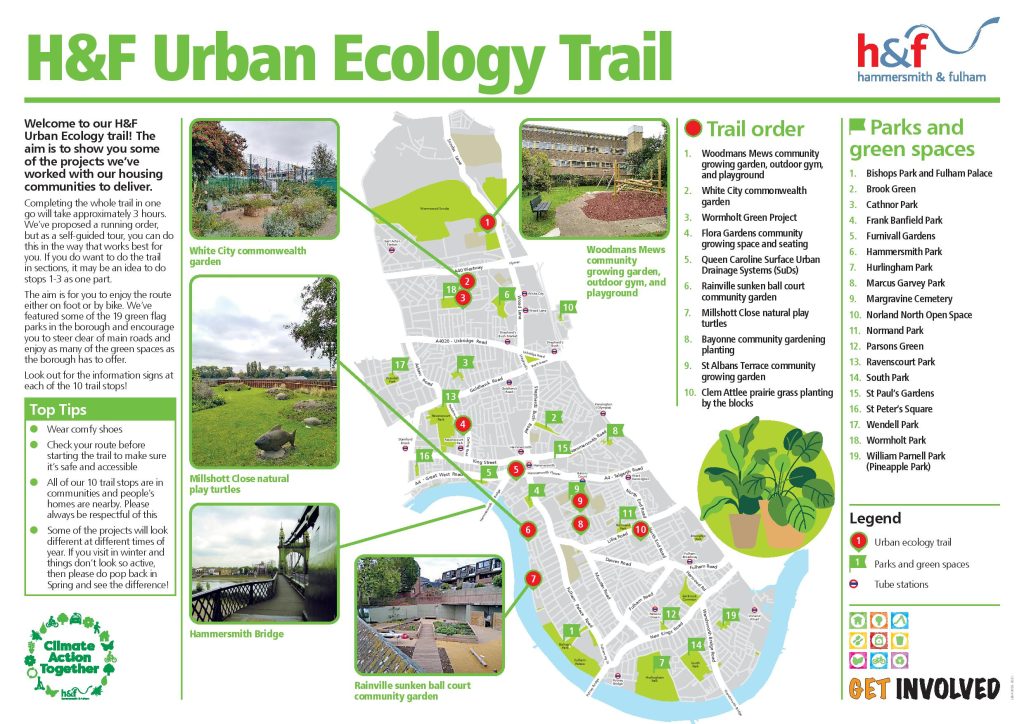
Welcome to our H&F Urban Ecology Trail, launched as part of the Climate Carnival! The aim is to showcase some of the projects we’ve worked with our housing communities to deliver.
Here’s the Urban Ecology Trail map and guide

More about the trail
Completing the whole trail in one go will take approximately 3 hours. We’ve proposed an order you can do this in, but as a self-guided tour, you can do this in the way that works best for you. If you do want to do the trail in sections, it may be an idea to do stops 1 – 3 as one part.
The aim is for you to enjoy the route either on foot or by bike. We’ve featured some of the 19 green flag parks in the borough and encourage you to avoid main roads and enjoy as many of the green spaces as the borough has to offer.
Follow the walking route we took here, or choose your own path through the borough!
Suggested routes and trail stop commentary
- Woodmans Mews Community Growing Garden Outdoor Gym, and Playground
There is a google maps location for Woodmans Mews Community Garden which takes you directly to it. For access from the main road, turn onto Woodmans Mews and walk straight down until you see the entrance to the gardens.
The garden is very beautiful and well maintained. The gym equipment also looks like it’s getting plenty of use. Gates were open, seating area was very accessible.
The walk to the next stop uses a lot of main roads, including crossing the A40. Pavements are narrow but pleasant when walking towards White City. This took 35 minutes.
- White City Commonwealth Garden
Aim for the White City Community Centre, India Way, London W12 7QT. The garden is between the Community Centre and the primary school. This flourishing garden is maintained by resident volunteers and Idverde community gardener volunteers.
The route to next stop is very quick. This took 10mins.
- Wormholt Green Project, Bloemfontein Corner Garden
This garden is very beautiful and well maintained. It’s a project we’re currently helping the community to progress further. It is a quick stop on the route and has seating.
The walk to next stop uses a lot of main roads and pavements are narrow but pleasant when walking towards Ravenscourt area. This took 35 minutes.
- Flora Gardens Community Growing Space
The growing space is located closest to the Dalling Road entrance. You need to take the first left when you get onto Flora Gardens and will then find the growing space easily.
Use the subway to walk to the next area. At the end of the subway, we entered and walked through Furnivall Gardens which was beautiful, with stunning views of the Thames & Hammersmith Bridge.
- Queen Caroline Surface Urban Drainage Systems (SuDs)
Very scenic view walking along the river when you get to it. It was easy to find, well maintained and had seating and signage.
The SuDs area is located to the right of Alexandra House, which is close to the river, on the Queen Caroline Estate. The walk to the next location was 10 mins.
- Rainville Sunken Ball Court Community Garden and recently added security prickly bushes and increased biodiversity
The next leg of the trail was along the Thames Path. Keep walking along the river path, as this location is 10 mins from Queen Caroline. It is at the back of Rainville Court.
Seeing the site at ground level does require the use of stairs if you wish to enter the sunken area, however you can view it from the Thames path. The walk to the next location was 10 mins.
- Millshott Close Turtles
The play space is easy to find and next to the Millshott Close estate. There is no visible seating in this area. It was about a 15 min walk to the next location.
- Bayonne Planting biodiverse planting and cherry trees
The planting area is next to the multi-use games area opposite the nursery. To access the estate from Bayonne Road, walk straight through the estate towards Bayonne park, and the planting area will be on the left before the park, next to the basketball court.
It was less than 10 mins to the next location.
- St Albans Terrace Community Garden, Field Road Estate
Nestled in next to St Albans Terrace is the community growing garden.
It was about a 25 min walk to the next location.
- Clem Attlee Court
End your trail by viewing the expanse of green areas on the Clem Attlee Estate, where there’s been lots of wildflower planting, prairie grass and beautiful rose bushes.
Top Tips
• Wear comfy shoes
• Check your route before starting the trail to make sure it’s safe and accessible
• All of our 10 trail stops are in communities and people’s homes are nearby. Please always be respectful of this
• Some of the projects will look different at different times of year. If you visit in winter and things don’t look so active, then please do pop back in Spring and see the difference!
Look out for the information signs at each of the 10 trail stops!
If you have missed any of the signs, you can download the information here.
